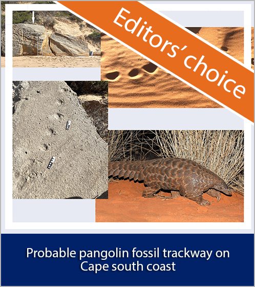
Quantifying the catchment salt balance: An important component of salinity assessments
DOI:
https://doi.org/10.17159/sajs.2015/20140196Keywords:
Berg River catchment, dryland, salt storage, soil salinity, hydrosalinity modellingAbstract
Soil and stream salinisation is a major environmental problem because it reduces the productivity of landscapes and degrades water quality. The Berg River (South Africa) has been exhibiting a trend of increasing salinity levels, which has primarily been attributed to the manifestation of dryland salinity. Dryland salinity occurs as a result of changes in land use (indigenous vegetation to agriculture and/or pasture), which cause a change in the water and salt balance of the landscape, consequently mobilising stored salts. The quantification of salinity fluxes at the catchment scale is an initial step and integral part of developing dryland salinity mitigation measures. The objective of this study was to quantify the salinity fluxes in the Sandspruit catchment, a tributary catchment of the Berg River. This included the quantification of salt storage, salt input (rainfall) and salt output (in run-off). The results of the catchment salt balance computations indicate that the Sandspruit catchment is exporting salts, i.e. salt output exceeds salt input, which may have serious implications for downstream water users. Interpolated regolith salt storage generally exhibited increasing storage with decreasing ground elevation. A salinity hotspot was identified in the lower reaches of the catchment. It is envisaged that the data presented in this study may be used to classify the land according to the levels of salinity present; inform land management decisions; and provide a guide and framework for the prioritisation of areas for intervention and the choice and implementation of salinity management options. The data which were generated may also be used to calibrate hydrosalinity models.

Downloads
Published
Issue
Section
License

All articles are published under a Creative Commons Attribution 4.0 International Licence
Copyright is retained by the authors. Readers are welcome to reproduce, share and adapt the content without permission provided the source is attributed.
Disclaimer: The publisher and editors accept no responsibility for statements made by the authors
How to Cite
- Abstract 488
- PDF 661
- EPUB 209
- XML 249
- Supplementary Material 126