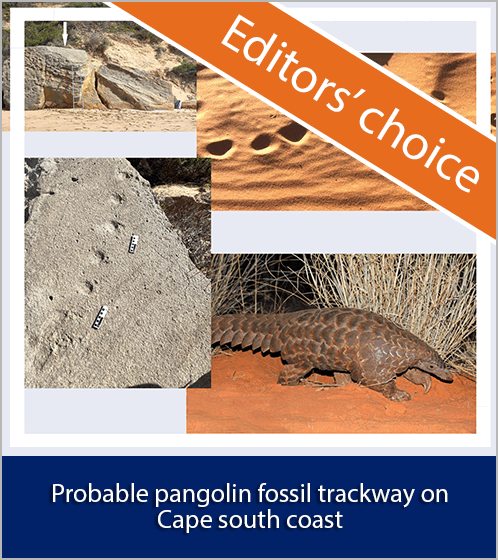
Corrigendum: Aerial map demonstrates erosional patterns and changing topography at Isimila, Tanzania
DOI:
https://doi.org/10.17159/sajs.2022/5911CAbstract
Original article: https://doi.org/10.17159/sajs.2019/5911
Due to an error in the reference plane, the elevation range shown for the digital elevation model (DEM) in Figure 5a is incorrect. The correct elevation range is 1629.41–1679.64 m. The DEM and orthomosaic map data were reprocessed using Agisoft Metashape 1.7.4. Processing parameters for the corrected DEM and orthomosaic differ slightly from those in Supplementary table 1 as a result of correcting the reference plane and differences in technical specifications of the computers used to process data. The corrected DEM, orthomosaic, and processing parameters are available for download at: https://doi.org/10.5281/zenodo.4592344. The corrected Figure 5 and Supplementary table 1 appear in the PDF. The error does not affect the interpretation of data in the original article.
We thank Rebecca Bateman and Richard Bates for bringing the error to our attention and for sharing their data, as well as Pastory Bushozi and Philbert Katto for sharing their field data.

Published
Issue
Section
License

All articles are published under a Creative Commons Attribution 4.0 International Licence
Copyright is retained by the authors. Readers are welcome to reproduce, share and adapt the content without permission provided the source is attributed.
Disclaimer: The publisher and editors accept no responsibility for statements made by the authors
How to Cite
- Abstract 431
- PDF 661
- EPUB 472
- XML 628